Walking the Plaques
Trail: A virtual walkaboutLoughborough, taking in plaques – blue, green, white
brown and others – which have been installed by various bodies to celebrate or
commemorate an important event, place or person in Loughborough’s history. Snippets
of info about the items in question accompany each picture. Devised and created
by lynneaboutloughborough.
Originally published
as a blog post, March 2018: https://lynneaboutloughborough.blogspot.com/2018/03/walking-plaques.html Enlarged, revised and updated April 2020.
There are
many commemorative plaques to be found around the town and on the edges of the
town, and they are a variety of colours. They’ve been installed by various bodies, and
where I know what this was, I've included info and/or a link. Where possible
I've included a photo of the actual plaque in question and a photo to show it
in context. I’ve also included a few things that aren’t strictly commemorative
plaques, just to add a bit of interest for you!
There are other
virtual walks on lynneaboutloughborough for you to try including the Lace and
Luddite Trail, the Zeppelin Trail, the Sculpture, Art and Architecture Trail, and
the Three Towers Trail.
So, let’s get
walking!
The plaques
are arranged in as logical a walking order as could possibly be managed, but this
isn’t a circular walk. We will begin our walk on Leicester Road, where it joins
Shelthorpe Road and end at the Midland Mainline railway station on Nottingham Road.
But, of course, you can choose to start wherever suits you best, and you can pick just to visit a couple of plaques in any area.
1
Location – archway at the bottom of the
Shelthorpe Estate at its junction with Leicester Road
Detail – coat of arms, showing various elements from the coat of arms of the Hastings family, and plaque concerning the planting of the trees in the area, both commemorating the award-winning, garden-city-style design that is the Shelthorpe Estate
What else
to see in the
general area – the cemetery chapels further up Leicester Road – the
Loughborough Endowed Schools buildings further down Leicester Road, on the left
– the Lodge to Aingarth (formerly Elms Lodge) also further down Leicester Road,
on the right.


2
Location – gate piers to the TA building
just beyond the bottom of the Shelthorpe Estate at its junction with Leicester
Road
Detail – Brown commemorative plaque,
installed by Charnwood Borough Council
What else
to see in the
general area – the Loughborough Endowed Schools buildings further down
Leicester Road, on the left – the Lodge to Aingarth (formerly Elms Lodge) also
further down Leicester Road, on the right.


3
Location – Factory Street on house next door to the Peacock
⏩ - turn right off Leicester Road
⏩ - turn right off Leicester Road
Detail – Green plaque commemorating the
innovative textile manufacturer William Cotton who lived in this property.
Installed by Leicestershire County Council
What else
to see in the
general area – a blue plaque back down Leicester Road – white plaque on the
gates to Southfield Park


4
Location – John Heathcoat’s House,
Leicester Road
⏩ - retrace your steps along Factory Street and turn right back onto Leicester Road
⏩ - retrace your steps along Factory Street and turn right back onto Leicester Road
Detail – Blue plaque commemorating the
lace-manufacturer John Heathcoat who was living in this property at the time
the Luddites attacked his factory on Mill Street (now Market Street) in 1816.
Installed by Charnwood Borough Council
What else
to see in the
general area – white plaque on gates to Southfield Park, just down Leicester
Road - Green Plaque further up Leicester Road and off to the left down Factory
Street


5
Location - Thomas Cook at Southfields
Park, Leicester Road, almost directly opposite Heathcoat's house
Detail – White plaque commemorating the
first “package tour” from Leicester to Loughborough, a Temperance Society
outing, including fun and games on Southfields Park
What else
to see in the
general area – Blue Plaque a little way down Leicester Road – a Green Plaque
further down Leicester Road and off to the left down Factory Street

6
Location – Council Offices on Southfields
Road
⏩ - turn left off Leicester Road
Detail – tiled mosaic featuring elements of the Hastings coat of arms on the floor directly in front of the entrance to the Charnwood Borough Council offices
What else
to see in the
general area – a Green Plaque
further down Southfield Road and past Park Road

7
Location – on house wall on Castledine
Street
⏩ - continue along Southfields Road, turn left into Victoria Street, follow it round into Burton Street, at the end of Burton Street turn left and immediately let into Stanley Street and then right at the end, where the house can be found a little way down on the right
⏩ - continue along Southfields Road, turn left into Victoria Street, follow it round into Burton Street, at the end of Burton Street turn left and immediately let into Stanley Street and then right at the end, where the house can be found a little way down on the right
Detail – Green plaque commemorating Kathleen
and Nora Corcoran, daughters of Dr Corcoran, who were active, local
Suffragettes. They lived in The Shanty, but the plaque has been placed on the
wall of the neighbouring house. Installed by Leicestershire County Council
What else
to see in the
general area – further down Castledine Street on the opposite side of the road a 1930s Art Deco Grade II listed garage, once owned by a member of the Taylors Bellfoundry.


8
Location – Town Hall, Market Place
⏩ – from Castledine Street/Stanley Road, turn right into Park Road, right into Burton Street, right into Victoria Street, cross Southfields Road at the pedestrian crossing (Noodle Bar and chip shop), and at the pedestrian crossing over Wood Gate, and turn right into Wards End. Continue straight down until you get to the Market Place
⏩ – from Castledine Street/Stanley Road, turn right into Park Road, right into Burton Street, right into Victoria Street, cross Southfields Road at the pedestrian crossing (Noodle Bar and chip shop), and at the pedestrian crossing over Wood Gate, and turn right into Wards End. Continue straight down until you get to the Market Place
Detail – Brown plaque commemorating the
mobilisation of the troops for WW1. Installed by Charnwood Borough Council
What else
to see in the
general area – Green plaque and artwork in the shopping centre

9
Location – entrance to Carillon Centre
from Market Street
⏩ – from the Town Hall, walk down Market Street and turn right down towards the entrance to the Carillon Court shopping centre
⏩ – from the Town Hall, walk down Market Street and turn right down towards the entrance to the Carillon Court shopping centre
Detail – Green plaque commemorating
Angel Yard, the former home of the publishers of Ladybird Books, before it
moved to Beeches Road. Installed by Leicestershire County Council
What else
to see in the general
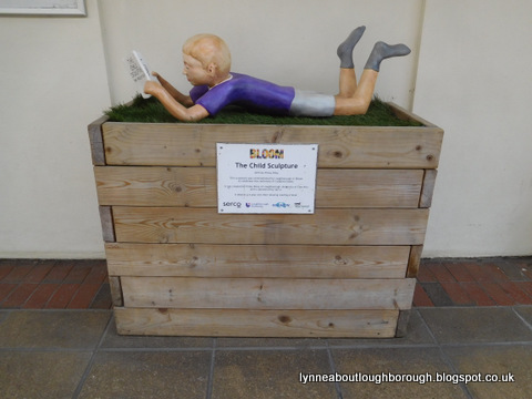
area – inside the centre and to the right is an artwork showing a boy lying down reading, situated in the Carillon
Centre


10
Location – entrance to Iceland on Market
Street
⏩ – retrace your steps from the Carillon Court shopping centre and turn right into Market Street. Continue down Market Street until you reach Iceland.
⏩ – retrace your steps from the Carillon Court shopping centre and turn right into Market Street. Continue down Market Street until you reach Iceland.
Detail – Green plaque commemorating the
former factory of John Heathcoat which was attacked by Luddites on the night of
29th June 1816. Installed by Leicestershire County Council
What else
to see in the
general area - Masonic Hall


11
Location – entrance to the Masonic Hall
(formerly the Carillon Rooms, and Independent Congregational Chapel) on Orchard
Street
⏩ – continue along Market Street to its junction with Ashby Square, cross to Orchard Street
⏩ – continue along Market Street to its junction with Ashby Square, cross to Orchard Street
Detail – commemorating 200 years of
Freemasonry, and 129 years of meetings in Loughborough. Installed by the
Provincial Grand Lodge of Leicestershire and Rutland.
What else
to see in the
general area – along Swan Street, a granite cross in the middle of the road,
and a commemorative plaque under the canopy of the stairs to The Rushes
shopping centre


12
Location – Swan Street a commemorative
plaque under the canopy of the stairs to The Rushes shopping centre
⏩ – walk along Orchard Street, at the end turn left into The Rushes
⏩ – walk along Orchard Street, at the end turn left into The Rushes
Detail – commemorating the site of the
falling of Zeppelin bombs on The Rushes, and those who were killed in the attacks.
Paid for by public subscription
What else
to see in the
general area – see also the granite cross in the middle of the road

13
Location – Bottom end of Church Gate at
its junction with Biggin Street
⏩ – walk back along The Rushes towards town, turn left into Biggin Street
⏩ – walk back along The Rushes towards town, turn left into Biggin Street
Detail – White plaque commemorating the
pedestrianisation of Church Gate in 1980 and installed by Loughborough and
District Civic Trust
What else
to see in the
general area – Blue Plaque a little way up Church Gate and off to the left down
Warners Lane


14
Location – a wall on Warner’s Lane, off
Church Gate
⏩ – walk up Church Gate and turn left into Warners Lane where the plaque can be seen on the left
⏩ – walk up Church Gate and turn left into Warners Lane where the plaque can be seen on the left
Detail – Blue plaque commemorating the former
Non-Conformist (Unitarian) Church which used to be in this area. Robert
Bakewell, prominent local agricultural pioneer attended this church.
Installed by Charnwood Borough Council
What else
to see in the
general area – white plaque at bottom of Church Gate at its junction with
Biggin Street


15
Location – notice about Henry VII
⏩ – continue along Warners Lane and at its end turn right into Biggin Street. At the top of Biggin Street. At the top of Biggin Street cross the top of Church Gate and cross at the pedestrian crossing. Continue along the upper part of Church Gate towards the church, but cross the road before reaching it
⏩ – continue along Warners Lane and at its end turn right into Biggin Street. At the top of Biggin Street. At the top of Biggin Street cross the top of Church Gate and cross at the pedestrian crossing. Continue along the upper part of Church Gate towards the church, but cross the road before reaching it
Detail – Lowe’s the furnishers has been
on this site for around 150 years, and the sign suggests that Henry VII may have stayed in this building
What else
to see - Blue and Green plaques at Taylors Bellfoundry

16
Location – a pair of plaques on part of
the Taylor Bellfounders factory on Freehold Street
⏩ – from the corner of Lowe’s building at the junction of Church Gate and Sparrow Hill, turn right into Sparrow Hill, cross at the pedestrian crossing, cross Sparrow Hill at the International supermarket, enter Cradock Street and turn immediately right into the housing estate. At the Mario Tinenti Centre building turn left and then take the path into the estate on the right. Follow the path through to the green, and then turn left and then right into Freehold Street. At the junction of Freehold Street and Cobden Street turn and look at the belltower
⏩ – from the corner of Lowe’s building at the junction of Church Gate and Sparrow Hill, turn right into Sparrow Hill, cross at the pedestrian crossing, cross Sparrow Hill at the International supermarket, enter Cradock Street and turn immediately right into the housing estate. At the Mario Tinenti Centre building turn left and then take the path into the estate on the right. Follow the path through to the green, and then turn left and then right into Freehold Street. At the junction of Freehold Street and Cobden Street turn and look at the belltower
Detail – Blue plaque commemorating the
life of John William Taylor I who worked and lived on the factory site,
1859-1906. Green plaque commemorating the work of the Bellfoundry at this site
since 1859, installed by Leicestershire County Council
What else
to see in the
general area – brass plaque on Empress Road


17
Location – Empress Road on the side of a
house near the Herbert Morris factory
⏩ – from the Bellfoundry, continue along Freehold Street, cross Queen’s Road and enter Empress Road. Continue down Empress Road, where the plaque will be found on the former factory on the left-hand side, directly after Robert Hardy Wharf.
⏩ – from the Bellfoundry, continue along Freehold Street, cross Queen’s Road and enter Empress Road. Continue down Empress Road, where the plaque will be found on the former factory on the left-hand side, directly after Robert Hardy Wharf.
Detail – brass plaque commemorating the
site of the falling of Zeppelin bombs, and those who were killed in the five
attacks.
What else
to see in the
general area – granite cross in the road opposite this plaque – blue and green
plaques on Freehold Street

18
Location – Gainsborough House on
Nottingham Road
⏩ – retrace your steps along Empress Road, turn right into Queen’s Road and at its end turn right into Nottingham Road. Continue down Nottingham Road where the house will be seen next to the Magnet kitchen shop
⏩ – retrace your steps along Empress Road, turn right into Queen’s Road and at its end turn right into Nottingham Road. Continue down Nottingham Road where the house will be seen next to the Magnet kitchen shop
Detail – Gainsborough House was the
home of Thomas Tyler who trained Sunloch, a horse which won the Grand National
in 1914. Installed by Leicestershire County Council
What else
to see in the
general area – a white plaque on the railway station building – plaque
commemorating the 50th anniversary of the creation of the
British Junior Chamber – artwork on the flats on Station Boulevard

19
Location - Thomas Cook at the railway
station
⏩ – the railway station is directly opposite Gainsborough House
⏩ – the railway station is directly opposite Gainsborough House
Detail – commemorating the first “package
tour” from Leicester to Loughborough, a Temperance Society outing, including
fun and games on Southfields Park
What else to see in the general area
– Loughborough Junior Chamber plaque also commemorating the outing on the
50th anniversary of the British Junior Chamber – a red
telephone box – a VR wall inset post-box – the GCR bridge over the mainline –
the artwork on the flats on Station Boulevard – a green plaque on a farmhouse
on Nottingham Road


You are welcome to quote passages from any of my posts, with appropriate credit. The correct citation for this looks as follow:
Dyer, Lynne (2020). Loughborough Plaque Trail. Available from: https://lynneaboutloughborough.blogspot.com/p/walkingthe-plaques-trail-walking.html [Accessed 3 May 2020]
Take down policy:
I post no pictures that are not my own, unless I have express permission so to do. All text is my own, and not copied from any other information sources, printed or electronic, unless identified and credited as such. If you find I have posted something in contravention of these statements, or if there are photographs of you which you would prefer not to be here, please contact me at the address listed on the About Me page, and I will remove these.
Thank you for reading this blog.
Lynne
Hello from France
ReplyDeleteI am looking for information on my ancestors who came from England and who were Tullist mechanics in the John Heathcoat factory.
Do you have an email address to join this story if you are interested?
Hugues
Hi Hugues from France! Thank you for reading the blog. Sadly, I don't know very mmuch about the lcae-makers who left England for France, so I might not be much help to you. My email address can be found on the About Me page. Thank you for commenting. Lynne
ReplyDeleteHave you ever seen a plaque for Margaret Bannister at any of the churches?
ReplyDeleteHi! No, I don't think I have, sorry. Lynne
Delete