Misplaced
milestones
A couple of weeks ago I wrote about a misplaced milestone outside the Organ Grinder pub, so today I thought I'd investigate another one - well,
actually, not a misplaced milestone, but a misplaced boundary marker!!!
Whilst out and about last weekend, I was particularly interested in the heritage
information boards around Quorn, and the maps of the local footpaths that are
in danger of being closed, as they are unrecorded. One of these is close to the
house called One Ash, and another is over the Woodthorpe Bridge across the
canal, and leads diagonally across the fields to the path that heads down to
the Moor Lane Bridge. It was this latter one that particularly interested me,
not least because it’s a route we often walk, but also because of its position,
approached from the Leicester Road, along the path that’s adjacent to the
Bull-in-the-Hollow farm.

Looking at an
old map, I was reminded that a parish boundary marker just beyond the turn into
the path, on the left as you go out of Loughborough towards Leicester, appears
on the map. The Ordnance Survey carried out a Boundary Survey between 1841 and
1888, which was a huge undertaking to record these across the country, and the
result of the survey was such that local administrative boundaries for the
whole of Great Britain were accurately mapped for the first ever time. Boundary
posts, plates, stones or markers appear on maps with various abbreviations,
like BP or BS: ours is BP.


In order to
provide information on their maps, about these boundaries, the OS gathered
information from local people who were familiar with the boundaries, and it was
following this that reform of local government areas first began. The year 1888,
was a landmark time in the history of the town, it being the year of the incorporation of the Borough
of Loughborough, which brought with it, of course, the position of mayor.
Anyway, to
boundaries!! To my mind, boundary changes are very tricky things!! Also, to my
mind, maps are tricky things!!
There are two
boundaries marked on a map dated 1885-1913, and two boundary posts, or boundary
plates, on the A6 as you travel towards Leicester, one before the
Bull-in-the-Hollow, and one just after it. The first boundary line is labelled
as “Munl. Boro. By.” Meaning:
The second
boundary line, that is, the Quorn side of the Bull-in-the-Hollow, is not
labelled on that stretch, but is on the stretch between Quorn Lodge and the
hamlet of Woodthorpe, where it says: “Union & U.D. By.”
It looks as
though there are still two boundaries on a map dated 1892-1914, and two
boundary posts, or boundary plates, as before, on the A6 as you travel towards
Leicester, the one before the Bull-in-the-Hollow, and the one just after it. The
name against the first of these boundaries (Municipal Borough Boundary) appears
to have gone, but the second one that comes just beyond the Bull-in-the-Hollow is
labelled along the adjacent path and clearly says: “Union and U.D. By.”.
As this later map is
post-incorporation, it looks as though the new boundary set at incorporation had been extended beyond
that marked by the first boundary post, up to the second boundary post, which was the start of Woodthorpe, and
this would seem to chime with the known extent of the reach of the Loughborough
Union (with its associations with the workhouse) and the Barrow-Upon-Soar
Union, of which Quorn was a part, but Woodthorpe was not.
This also
chimes with some of the discussions reported in the newspapers about which
areas were, and which areas weren’t to be included in the new Borough of
Loughborough, created in 1888.
In 1887,
after much discussion, it was decided to apply for a charter of incorporation for
the town of Loughborough, and in November that year, an inquiry was held at
which many aspects, both for and against such an application were discussed.
The ‘Nottingham Evening Post’ of 4th November 1887 carried the following
report:
“THE
PROPOSED INCORPORATION OF LOUGHBOROUGH: OFFICIAL INQUIRY THIS DAY.
This morning
the Hon. T.W. Pelham, barrister-at-law, the commissioner appointed by the Lords
of her Majesty’s Privy Council, opened an inquiry at the Town Offices,
Loughborough, to take evidence in reference to the application for a charter of
incorporation for the town of Loughborough, according to the provisions of the
Municipal Incorporations Act, 1882.”
During this
inquiry there was much discussion concerning the proposed boundaries, and
several people expressed their opinion about where these should be, and what
parts of the area should be included:
“Mr H. Humphreys,
on behalf of Mrs Perry Herrick, of Beaumanor, applied to the Commissioner that
the hamlet of Woodthorpe and Outwoods should not be included in the corporation
of the borough of Loughborough.
In reply to
the Commissioner, Mr Humphreys stated that there were 14 inhabited houses in
Woodthorpe. He believed the children went to school at Loughborough, but some
might go to Quorndon. He stated that Woodthorpe had a separate existence,
collecting its own rates and electing its Guardians [of the Poor law]. It was
entirely outside Loughborough for sanitary reasons, and for Local Board
reasons. It was connected with Loughborough by a mistake of the Commissioners
in 1848, and he might say it was entirely outside of Loughborough for any water
supply or light.
Mr Jarratt [Clerk
to the Local Board] contended that the fortunes of Woodthorpe had been united
to those of Loughborough for the last 37 years, and that the children went to
the Loughborough schools. He believed the whole of the inhabitants came to
Loughborough Church. If Woodthorpe were detached from the Local Board district
Mr Humphreys would find that the rates would be as large if not larger than at
present. He might say that the petitioners would not object to Woodthorpe being
outside the borough boundary.
The
Commissioner observed that 5,000 acres was a large area for a population like
that of Loughborough. Last year, three places which petitioned for charters in
Lancashire were all refused, because they had too much area, two having a
population of 20,000 and one of nearly 30,000. What was good for a Local Board
was not necessarily good for a borough.
Mr Jarrett
said they were so convinced in the matter that they were not anxious to retain
Woodthorpe if Mrs Perry Herrick wished it. They were quite willing that it be
left outside. (Applause).
Mr Hodson
proceeded to state that if Woodthorpe did not belong to a wealthy lady (Mrs
Perry Herrick), it would now be a popular residential suburb of Loughborough.
Land in that neighbourhood was increasing in value day after day simply because
of the prosperity of Loughborough.
Mr Gordon
said that he supported the application for the charter, but asked that the
Outwood Farm be left outside the boundary.
Mr Godkin and
Mr Humphreys were requested to forward plans to the Commissioner.
Mr C.H.
Adams, Mr E. Jarratt, and Mr J. Corah spoke as to the correctness of signatures
to the petition, and Mr Newman verified the amount of rateable value.
The
Commissioner in closing the inquiry, said he would not express his opinion
about the application, as it was a matter for the Lords of the Privy Council to
decide whether a charter should be granted. He would be able to report as to
the feeling of the town being unanimously in favour of a Corporation. He would
also report as to the boundaries, and let it be known as soon as possible. He
would be glad to know what extent of property belonged to those who objected to
the inclusion of their parts of the district in the new borough.”
Reports of
progress towards incorporation appeared in various newspapers, including this
report in the ‘Leicester Chronicle’ of 14th January 1888:
“THE
PROPOSED INCORPORATION OF LOUGHBOROUGH
We understand
that the application of the inhabitants of Loughborough for a charter of
incorporation has been favourably received by the Lords of the Privy Council.
On Thursday, Mr Jarrett, clerk to the Loughborough Local Board, received a
communication from the Hon. T.W.H. Pelham, the commissions who held the inquiry
in November last, requesting him to submit plans and a description of the
boundaries of the parish as suggested by the commissioner, together with a
description of the boundaries of the proposed borough. In the communication it
is hinted that in all probability Woodthorpe and some of the rural portions of
the parish of Loughborough will be eliminated from the charter. It is therefore
possible that only 3,000 out of the 5,000 acres of land will be included in the
parish. The Hon. T.W.H. Pelham will shortly visit Loughborough to arrange
definitely upon the boundaries.”
The ‘Melton
Mowbray Mercury and Oakham and Uppingham News’ reported on another meeting in the
Town Hall, in its issue of 16th February 1888:
“THE PROPOSED
INCORPORATION OF LOUGHBOROUGH: THE BOUNDARIES QUESTION
…the Hon,
T.W.H. Pelham … held an inquiry at the Town
Offices, Loughborough, with respect to the boundaries of the proposed borough.
The Commissioner stated that he had reported to the Privy Council the result of
his inquiries on the last occasion, and the Privy Council, without giving an
actual decision as to the application, which could nor be done until a draft of
the charter was submitted to the Queen, expressed an opinion that some of the more
rural parts of the present district should be omitted – the hamlet of
Woodthorpe and the more southerly part of the parish of Loughborough. The
reasons which led him to recommend that course to the Privy Council were that
that part of the present district was entirely rural in its character… ”
The article
goes on to explain that rural areas were sometimes unable to raise enough money
to maintain their roads, so such parishes were part of the Local Board, but
that incorporation was a different matter. Land value was also different, but
rates charged would be the same. Further mention was made that a local board
was a temporary set-up and could be changed at any time by the Local Government
Board, whereas a municipal borough could only be changed by parliament. Further
comment about Woodthorpe continued thus:
“The hamlet
of Woodthorpe was a separate poor law parish, which could not be said to be
urban, and which had a centre of its own. It was not dependent to any great
extent on Loughborough, and the same might be said of the southern part of Loughborough
parish. These were not entirely dependent upon Loughborough for their labour,
and it was thought by the privy Council that that part should be omitted.
There follows
some long and complex discussion about where the actual boundaries should fall,
before the Commissioner “proceeded to examine the plan of the proposed
boundaries with the object of fixing them…[saying] it had been a pleasure to
him to pay another visit to Loughborough, and he was glad the latter had been
so simple. He did not think there would be any great injustice done. It was the
right thing to exclude the southern portion of the parish. This concluded the
public enquiry.”
On 7th March
1888, the Nottingham Evening Post reported the following news:
“INCORPORATION
OF LOUGHBOROUGH
We learn that
the Privy Council have set the boundaries of the proposed borough, which are practically
the same as those suggested by the Commissioner at the inquiry on 10th ult
[Feb 1888]. The part of the township of Loughborough lying to the south of a
line drawn by the side of the occupation roads leading from the Parks Farm
across the Park Road and Park Lane to Forest Lane, and then to and along the
boundary of Burleigh Park to Ashby Road, also the detached portions of
Knightthorpe, are excluded from the borough. The detached portions of Thorpe
Acre are within the boundary. The division of the borough into wards has also been
approved, and the Privy Council suggest that provision should be made for six
councillors to each ward with six aldermen to form a Town Council of 24 members.”
Of course, consideration
and a resulting decision upon the granting of a charter takes quite some time,
so it wasn’t until 15th August 1888 that the ‘Nottingham Post’ was able
to carry the following headline:
“THE INCORPORATION
OF LOUGHBOROUGH: THE CHARTER GRANTED”
In its
publication of 18th August 1888, the Leicester Chronicle included a copy of the
confirmatory letter that had been received by Mr Jarratt:
“Council Office,
11th August 1888. Gentlemen, I am directed by the Lord President of the Council
to inform you, with reference to the petition of the inhabitant householders of
the borough of Loughborough for the grant of a municipal charter to that borough,
that her Majesty has been pleased to comply with the prayer of the petitioners,
and has approved of the draft of a charter. The draft of the charter will be
issued to the Home Office in the course of a few days, and to that department
any further communication on the subject should be addressed… C. L. Peel,
Messrs. Sharpe and Co..”
The ‘Leicester
Daily Post’ further commented, on 8th September 1888:
“The charter
recently granted for the incorporation of Loughborough came into operation
yesterday, and from henceforth the second town of importance in this county
will be governed by a municipal corporation.”
The report
goes on to say that although the district was created a borough, it “does not include
the whole of the parish”.
Thus, if I’ve
understood all this correctly, Woodthorpe found itself outside of the new
municipal borough, and the boundary post sited before the Bull-in-the-Hollow,
as one leaves Loughborough, heading to Leicester, is the one that should be
there post-1888, and the one sited after the Bull-in-the-Hollow is therefore
redundant. What happened to the marker on the new boundary I have no idea, but
it seems the other one somehow made its way to the hamlet of Woodthorpe itself,
and sits proudly next to the entrance of a farm on Main Street, Woodthorpe.
Word on the street is that this was rescued from being disposed of sometime in
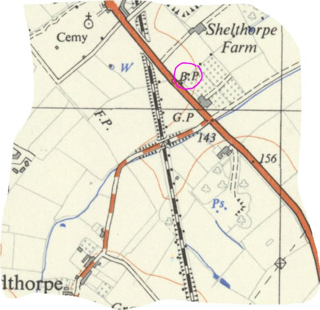
the 1960s. A 1937-1961 map shows only the first boundary marker:
As does the map 1945-1965:
I'm pretty sure I've contradicted myself somewhere in this post, but to be honest I've a little more than confused myself in trying to clarify how and why the Woodthorpe boundary marker moved!! Ah well... At least the description of the incorporation of the borough is a bit more succinct in 'A-Z of Loughborough'!
Posted by lynneaboutloughborough 29 August 2021
You are welcome to quote passages from any of my posts, with appropriate credit. The correct citation for this looks as follow:
Take down policy:
I post no pictures that are not my own, unless I have express permission so to do. All text is my own, and not copied from any other information sources, printed or electronic, unless identified and credited as such. If you find I have posted something in contravention of these statements, or if there are photographs of you which you would prefer not to be here, please contact me at the address listed on the About Me page, and I will remove these.
You can leave comments below, but do check back as my reply will appear here, below your comment.
Thank you for reading this blog.
Lynne