Showing posts with label maps. Show all posts

Sunday, 29 August 2021

Misplaced milestones

Misplaced milestones 


A couple of weeks ago I wrote about a misplaced milestone outside the Organ Grinder pub, so today I thought I'd investigate another one - well, actually, not a misplaced milestone, but a misplaced boundary marker!!!

Whilst out and about last weekend, I was particularly interested in the heritage information boards around Quorn, and the maps of the local footpaths that are in danger of being closed, as they are unrecorded. One of these is close to the house called One Ash, and another is over the Woodthorpe Bridge across the canal, and leads diagonally across the fields to the path that heads down to the Moor Lane Bridge. It was this latter one that particularly interested me, not least because it’s a route we often walk, but also because of its position, approached from the Leicester Road, along the path that’s adjacent to the Bull-in-the-Hollow farm.


Looking at an old map, I was reminded that a parish boundary marker just beyond the turn into the path, on the left as you go out of Loughborough towards Leicester, appears on the map. The Ordnance Survey carried out a Boundary Survey between 1841 and 1888, which was a huge undertaking to record these across the country, and the result of the survey was such that local administrative boundaries for the whole of Great Britain were accurately mapped for the first ever time. Boundary posts, plates, stones or markers appear on maps with various abbreviations, like BP or BS: ours is BP.


In order to provide information on their maps, about these boundaries, the OS gathered information from local people who were familiar with the boundaries, and it was following this that reform of local government areas first began. The year 1888, was a landmark time in the history of the town, it being  the year of the incorporation of the Borough of Loughborough, which brought with it, of course, the position of mayor.

Anyway, to boundaries!! To my mind, boundary changes are very tricky things!! Also, to my mind, maps are tricky things!!

There are two boundaries marked on a map dated 1885-1913, and two boundary posts, or boundary plates, on the A6 as you travel towards Leicester, one before the Bull-in-the-Hollow, and one just after it. The first boundary line is labelled as “Munl. Boro. By.” Meaning:


The second boundary line, that is, the Quorn side of the Bull-in-the-Hollow, is not labelled on that stretch, but is on the stretch between Quorn Lodge and the hamlet of Woodthorpe, where it says: “Union & U.D. By.”


It looks as though there are still two boundaries on a map dated 1892-1914, and two boundary posts, or boundary plates, as before, on the A6 as you travel towards Leicester, the one before the Bull-in-the-Hollow, and the one just after it. The name against the first of these boundaries (Municipal Borough Boundary) appears to have gone, but the second one that comes just beyond the Bull-in-the-Hollow is labelled along the adjacent path and clearly says: “Union and U.D. By.”.


As this later map is post-incorporation, it looks as though the new boundary set at incorporation had been extended beyond that marked by the first boundary post, up to the second boundary post, which was the start of Woodthorpe, and this would seem to chime with the known extent of the reach of the Loughborough Union (with its associations with the workhouse) and the Barrow-Upon-Soar Union, of which Quorn was a part, but Woodthorpe was not.

This also chimes with some of the discussions reported in the newspapers about which areas were, and which areas weren’t to be included in the new Borough of Loughborough, created in 1888.

In 1887, after much discussion, it was decided to apply for a charter of incorporation for the town of Loughborough, and in November that year, an inquiry was held at which many aspects, both for and against such an application were discussed. The ‘Nottingham Evening Post’ of 4th November 1887 carried the following report:

THE PROPOSED INCORPORATION OF LOUGHBOROUGH: OFFICIAL INQUIRY THIS DAY

This morning the Hon. T.W. Pelham, barrister-at-law, the commissioner appointed by the Lords of her Majesty’s Privy Council, opened an inquiry at the Town Offices, Loughborough, to take evidence in reference to the application for a charter of incorporation for the town of Loughborough, according to the provisions of the Municipal Incorporations Act, 1882.”

During this inquiry there was much discussion concerning the proposed boundaries, and several people expressed their opinion about where these should be, and what parts of the area should be included:

“Mr H. Humphreys, on behalf of Mrs Perry Herrick, of Beaumanor, applied to the Commissioner that the hamlet of Woodthorpe and Outwoods should not be included in the corporation of the borough of Loughborough.

In reply to the Commissioner, Mr Humphreys stated that there were 14 inhabited houses in Woodthorpe. He believed the children went to school at Loughborough, but some might go to Quorndon. He stated that Woodthorpe had a separate existence, collecting its own rates and electing its Guardians [of the Poor law]. It was entirely outside Loughborough for sanitary reasons, and for Local Board reasons. It was connected with Loughborough by a mistake of the Commissioners in 1848, and he might say it was entirely outside of Loughborough for any water supply or light.

Mr Jarratt [Clerk to the Local Board] contended that the fortunes of Woodthorpe had been united to those of Loughborough for the last 37 years, and that the children went to the Loughborough schools. He believed the whole of the inhabitants came to Loughborough Church. If Woodthorpe were detached from the Local Board district Mr Humphreys would find that the rates would be as large if not larger than at present. He might say that the petitioners would not object to Woodthorpe being outside the borough boundary.

The Commissioner observed that 5,000 acres was a large area for a population like that of Loughborough. Last year, three places which petitioned for charters in Lancashire were all refused, because they had too much area, two having a population of 20,000 and one of nearly 30,000. What was good for a Local Board was not necessarily good for a borough.

Mr Jarrett said they were so convinced in the matter that they were not anxious to retain Woodthorpe if Mrs Perry Herrick wished it. They were quite willing that it be left outside. (Applause).

Mr Hodson proceeded to state that if Woodthorpe did not belong to a wealthy lady (Mrs Perry Herrick), it would now be a popular residential suburb of Loughborough. Land in that neighbourhood was increasing in value day after day simply because of the prosperity of Loughborough.

Mr Gordon said that he supported the application for the charter, but asked that the Outwood Farm be left outside the boundary.

Mr Godkin and Mr Humphreys were requested to forward plans to the Commissioner.

Mr C.H. Adams, Mr E. Jarratt, and Mr J. Corah spoke as to the correctness of signatures to the petition, and Mr Newman verified the amount of rateable value.

The Commissioner in closing the inquiry, said he would not express his opinion about the application, as it was a matter for the Lords of the Privy Council to decide whether a charter should be granted. He would be able to report as to the feeling of the town being unanimously in favour of a Corporation. He would also report as to the boundaries, and let it be known as soon as possible. He would be glad to know what extent of property belonged to those who objected to the inclusion of their parts of the district in the new borough.”

Reports of progress towards incorporation appeared in various newspapers, including this report in the ‘Leicester Chronicle’ of 14th January 1888:

THE PROPOSED INCORPORATION OF LOUGHBOROUGH

We understand that the application of the inhabitants of Loughborough for a charter of incorporation has been favourably received by the Lords of the Privy Council. On Thursday, Mr Jarrett, clerk to the Loughborough Local Board, received a communication from the Hon. T.W.H. Pelham, the commissions who held the inquiry in November last, requesting him to submit plans and a description of the boundaries of the parish as suggested by the commissioner, together with a description of the boundaries of the proposed borough. In the communication it is hinted that in all probability Woodthorpe and some of the rural portions of the parish of Loughborough will be eliminated from the charter. It is therefore possible that only 3,000 out of the 5,000 acres of land will be included in the parish. The Hon. T.W.H. Pelham will shortly visit Loughborough to arrange definitely upon the boundaries.”

The ‘Melton Mowbray Mercury and Oakham and Uppingham News’ reported on another meeting in the Town Hall, in its issue of 16th February 1888:

THE PROPOSED INCORPORATION OF LOUGHBOROUGH: THE BOUNDARIES QUESTION

…the Hon, T.W.H. Pelham  … held an inquiry at the Town Offices, Loughborough, with respect to the boundaries of the proposed borough. The Commissioner stated that he had reported to the Privy Council the result of his inquiries on the last occasion, and the Privy Council, without giving an actual decision as to the application, which could nor be done until a draft of the charter was submitted to the Queen, expressed an opinion that some of the more rural parts of the present district should be omitted – the hamlet of Woodthorpe and the more southerly part of the parish of Loughborough. The reasons which led him to recommend that course to the Privy Council were that that part of the present district was entirely rural in its character… ”

The article goes on to explain that rural areas were sometimes unable to raise enough money to maintain their roads, so such parishes were part of the Local Board, but that incorporation was a different matter. Land value was also different, but rates charged would be the same. Further mention was made that a local board was a temporary set-up and could be changed at any time by the Local Government Board, whereas a municipal borough could only be changed by parliament. Further comment about Woodthorpe continued thus:

“The hamlet of Woodthorpe was a separate poor law parish, which could not be said to be urban, and which had a centre of its own. It was not dependent to any great extent on Loughborough, and the same might be said of the southern part of Loughborough parish. These were not entirely dependent upon Loughborough for their labour, and it was thought by the privy Council that that part should be omitted.

There follows some long and complex discussion about where the actual boundaries should fall, before the Commissioner “proceeded to examine the plan of the proposed boundaries with the object of fixing them…[saying] it had been a pleasure to him to pay another visit to Loughborough, and he was glad the latter had been so simple. He did not think there would be any great injustice done. It was the right thing to exclude the southern portion of the parish. This concluded the public enquiry.”

On 7th March 1888, the Nottingham Evening Post reported the following news:

INCORPORATION OF LOUGHBOROUGH

We learn that the Privy Council have set the boundaries of the proposed borough, which are practically the same as those suggested by the Commissioner at the inquiry on 10th ult [Feb 1888]. The part of the township of Loughborough lying to the south of a line drawn by the side of the occupation roads leading from the Parks Farm across the Park Road and Park Lane to Forest Lane, and then to and along the boundary of Burleigh Park to Ashby Road, also the detached portions of Knightthorpe, are excluded from the borough. The detached portions of Thorpe Acre are within the boundary. The division of the borough into wards has also been approved, and the Privy Council suggest that provision should be made for six councillors to each ward with six aldermen to form a Town Council of 24 members.”

Of course, consideration and a resulting decision upon the granting of a charter takes quite some time, so it wasn’t until 15th August 1888 that the ‘Nottingham Post’ was able to carry the following headline:

THE INCORPORATION OF LOUGHBOROUGH: THE CHARTER GRANTED

In its publication of 18th August 1888, the Leicester Chronicle included a copy of the confirmatory letter that had been received by Mr Jarratt:

“Council Office, 11th August 1888. Gentlemen, I am directed by the Lord President of the Council to inform you, with reference to the petition of the inhabitant householders of the borough of Loughborough for the grant of a municipal charter to that borough, that her Majesty has been pleased to comply with the prayer of the petitioners, and has approved of the draft of a charter. The draft of the charter will be issued to the Home Office in the course of a few days, and to that department any further communication on the subject should be addressed… C. L. Peel, Messrs. Sharpe and Co..”

The ‘Leicester Daily Post’ further commented, on 8th September 1888:  

“The charter recently granted for the incorporation of Loughborough came into operation yesterday, and from henceforth the second town of importance in this county will be governed by a municipal corporation.”

The report goes on to say that although the district was created a borough, it “does not include the whole of the parish”.

Thus, if I’ve understood all this correctly, Woodthorpe found itself outside of the new municipal borough, and the boundary post sited before the Bull-in-the-Hollow, as one leaves Loughborough, heading to Leicester, is the one that should be there post-1888, and the one sited after the Bull-in-the-Hollow is therefore redundant. What happened to the marker on the new boundary I have no idea, but it seems the other one somehow made its way to the hamlet of Woodthorpe itself, and sits proudly next to the entrance of a farm on Main Street, Woodthorpe. Word on the street is that this was rescued from being disposed of sometime in the 1960s. A 1937-1961 map shows only the first boundary marker:
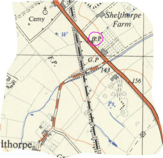


As does the map 1945-1965:


I'm pretty sure I've contradicted myself somewhere in this post, but to be honest I've a little more than confused myself in trying to clarify how and why the Woodthorpe boundary marker moved!! Ah well... At least the description of the incorporation of the borough is a bit more succinct in 'A-Z of Loughborough'! 

Posted by lynneaboutloughborough 29 August 2021

You are welcome to quote passages from any of my posts, with appropriate credit. The correct citation for this looks as follow:

Dyer, Lynne (2021). Misplaced milestones. Available fromhttps://lynneaboutloughborough.blogspot.com/2021/08/misplaced-milestones.html   [Accessed 29 August 2021]

Take down policy:
I post no pictures that are not my own, unless I have express permission so to do. All text is my own, and not copied from any other information sources, printed or electronic, unless identified and credited as such. If you find I have posted something in contravention of these statements, or if there are photographs of you which you would prefer not to be here, please contact me at the address listed on the About Me page, and I will remove these.

You can leave comments below, but do check back as my reply will appear here, below your comment.

Thank you for reading this blog. 

Lynne      

Sunday, 31 May 2020

Researching your house through time

Researching the history of your house
I've read in the news recently that since the outbreak of coronavirus, and the government rules about not going out, many people have been turning to discovering the local history of their village, town or area. Along with that, there’s a new series just begun on television of ‘A House Through Time’. Not a programme I’ve seen much of before, but a fascinating look at one house and its history, and in the case of this particular house, its history from the time it was first built.

As someone who is interested in local history, I’ve always been fascinated by who lived where, and what they did for a living, and where they came from and moved to, if indeed they did move! Usually, my research only takes me up to the early twentieth century, as I try to respect the 100 year rule, and certainly don’t want to upset any living relatives. However, a few Christmases ago (when I say a few, it was probably about 10 – I tend to forget how quickly time flies!) I briefly researched the history of my own and my neighbour’s house, and popped the details into a Christmas card. I do appreciate that in doing this, I broke my own rules, but that was because the houses were built in the second half of the twentieth century, so the history was fairly new – and also fairly short!!! – and it was for personal use only.

In the process of doing that research, I learned quite a lot about how to go about finding the information I needed. I appreciate that I am lucky because I have a personal subscription to both Ancestry and FindMyPast, on which there are hundreds of resources, but we in Loughborough are also lucky because of the myriad physical resources we have at our disposal.

You may be interested in researching the history of your house – when it was built, who lived in it, what sort of area it was in, and maybe if there have been any major alterations to it. Here’s some of the resources I’ve found useful in my research and some hints and tips for researching the history of your own house. This is by no means a comprehensive list, but it might give you a starting point.

Street directories
What? A street directory is an alphabetical list of streets and roads. Under each street name, properties – often residential, sometimes otherwise - are listed by their property number, and any house with only a name will appear in its correct position relative to the numbered houses adjacent. The alphabetical listing makes it fairly easy to find a specific street, unless it happens to be off another street, and therefore listed under the latter.
Who? A street directory can tell you who lived in a particular property, but will generally only list the head of the household, so, you won’t be able to find family information.
When? Street directories might be published in any year, and might appear annually, or less often. If your street isn’t listed in a particular directory, try an earlier one, or a later one, as this will help you to discover the approximate date your house was built.
Where? Loughborough Public Library, in the area called the Local and Family History Centre, hold a set of Loughborough street directories going back into the nineteenth century and into the twentieth (I’d tell you the exact range, but I can’t remember, and the library is currently closed, so it’s not easy to check). Occasionally, second-hand copies of street directories are available from booksellers.

Extract from a 1952 street directory
Census returns
What? Census returns are the results of a nationwide survey of every household on a specific night in a specific year. The results are recorded at parish level, and within that in a logical geographical location order, so replicating the progression of the streets, rather than alphabetically. In earlier census returns, house numbers are not included, but in later ones, as well as there being an item number, where the house is numbered, this also appears.
Who? Each person in a household on the night of the survey is listed. Although the details vary slightly across each census, the sorts of information that can be found include forename and surname; age (approximate); marital status; relationship to the head of the household; occupation; whether an employer or an employee; and county and town of birth. Sometimes people living at an address are not listed at that address because they were away on the night, and sometimes visitors are listed at the place they were visiting because that’s where they were on the night. Workhouses, schools and hospitals usually list all the people there on the night of the census.
When? The surveys were – and still are – taken on one evening every 10 years, apart from a few exceptions (e.g. 1941), and are made available to the public 100 years after they were recorded, although, the exception to this is the 1939 register which is already available. I believe the 1921 census returns will be made public in January 2022. If your house isn’t listed on a particular census, try the earlier one and the later one, just as you would with the street directory.
Where? Access to census returns are available through subscription websites like Ancestry, FindMyPast and Genes Reunited: one can take out a personal subscription, or members of the public library can access selected ones through their library membership. Free access is also available at the National Archives, and FindMyPast is freely available at the Record Office for Leicester,Leicestershire and Rutland. I’m sure there are plenty of other websites that provide access to census returns, at varying costs. 
Extract from the 1891 census for Ashby Road


Extract from the 1891 census for Oxford Street


Trade directories
What? Trade directories are very similar to street directories, but they often include a short history of a place, and an alphabetical list of people and businesses, rather than an alphabetical list of streets. Trade directories usually cover a larger geographical area than a street directory, although a street directory may include trading addresses too. Loughborough may be contained in a directory that covers Leicestershire, or Leicestershire and Rutland, or even in a volume also dealing with Lincolnshire.
Who? Like street directories, the information about the residents is restricted to naming the head of the household. A person may be listed more than once, under both business and residential address. Address details can vary depending upon the publication.
When? Early trade directories were generally published irregularly. Examples include Pigot’s and Kelly’s. A later example would be the Yellow Pages, which were published annually, but only include trade and business detail: personal detail (again, just listing, in this case, the bill-payer!) being restricted to one person.
Where? Like census returns, trade directories are available through subscription websites, from the public library and the record office, and some have been digitised. Leicester University have a collection of the latter. 

Extract from an 1876 trade directory showing private residents and commercial properties
Maps (can help to date a house)
What? I think we all know what a map is! An old street map can help to establish an approximate date for the building of your house: if it doesn’t appear on the map one year, try and earlier map and a later map. The main problem I find with maps is that they rarely have printed on them the date they were compiled or printed! An easy-ish way round that is to look at the cost of the map, particularly if you’re looking at a set by the same publisher.
Who? A map will not tell you anything about the previous inhabitants of your house. It might, however, indicate a change of use if, for example your house used to be a pub.
When? Maps have been in constant development since they were first drawn, so there is a rich body of resources available for most towns.
Where? I recently went into a local booksellers to buy a current map of Loughborough. Naturally, I assumed that the one they had on the shelves was the latest edition and so I bought it. When I got it home and looked at it properly, I surmised it was about 5 years out-of-date. These days, folk seem to rely more on Google street maps. Having said that, if you’re looking for older maps, these often appear in charity shops, or second-hand books shops. Also, there are a variety available to view online. The public library and the Record Office also hold a collection of maps across the ages.

Extract of a 1901 map showing Burton Street without its more recent in-fill houses
Specialist publications, e.g. directories of professional bodies (like engineers etc.); registers of electors; land tax records; architectural drawings
What? Specialist directories exist for all manner of groups of people, including doctors, architects, dentists, Freemasons, and so on. Land tax records record ownership of properties and land, although this may not be the place of residence of the owner.
Who? These are membership directories, so only include information on people who are registered members.
When? Time coverage will depend upon when the institution was created, and if it is still going, or if it has ceased. Some directories are published annually, some less frequently.
Where? Some directories are still published in hard copy form, but many are now online, and probably subscription based. A selection of historical directories can be found on Ancestry.
Extract from a professional register

Newspaper articles
What? Local newspapers can be quite informative about people and properties. Information may appear in news articles, in entertainment news, in sports news, in reports of criminal activity, and so on. Although exact addresses are rare, knowing the name of at least one person who lived in your street can help you find out more about your own property.
Who? All manner of people can be mentioned in newspaper articles, but, depending upon the era you are researching, these are more often the ‘great and the good’, or those who may have committed a misdemeanour.
When? National newspapers go way back, so, for example, ‘The London Gazette’ was started in 1666, and in my experience, it’s useful as it lists bankruptcies and the dissolving of partnerships, although generally addresses given are the corporate ones, rather than the residential ones. Having said that, there are early forerunners of newspapers going back as far as 1513, but our local newspapers tend to start around the mid-1800s. As I write, we still have a weekly local paper, ‘The Loughborough Echo’, and also a regional paper, ‘The Leicester Mercury’.
Where? Microfilm copies of the local newspapers can be found in the Loughborough public library, and in the record office. Some titles and issues have been digitised and are available through subscription websites like FindMyPast or the British Library.

Extract from a newspaper advertising an auction

Wills and probate records
What? Like every birth and every marriage, every death is registered with the General Register Office, and a register of such events is produced. Once probate has been proved and granted, this is also produced as a register.
Who? A probate record, as well as providing personal detail of the deceased, often includes their last permanent address, which could now be your home. A will may also be available and will usually contain some detail about the abode of the person at the time they made the will, and that could now be your home.
When? A probate record is produced after probate is granted, which can sometimes take years.
Where? Probate records are available through Ancestry and FindMyPast, but only up to 1995.

Probate record for Thomas Corcoran who lived in Loughborough, but died elsewhere
House deeds
What? House deeds are the correspondence connected with the purchase of your house, going back to at least the time the house was built, and often to ownership of the land prior to the house being constructed. These documents include the local search results, the conveyance document itself, and a variety of other correspondence, sometimes including details of mortgage agreements. 
Who? These documents should tell you exactly who owned your house before you did, and going back to who owned the land it was built on. Other supplementary details can add to information about the local area, as they include details of witnesses to signatures, solicitor’s details, building society details, and sometimes even more.
When? These documents will give the complete history of your house going back beyond the time your house was built.
Where? When you buy a house, the deeds are usually kept for safety by the mortgage lender, or perhaps the solicitor. Since most of these records are now digitised (although still kept securely) it is possible that they are returned to you, the latest owner of your property.

Extract from house deeds showing previous ownership
Planning applications
What? Major alterations and additions to a property often require permission from the local council, although these regulations are subject to change.
Who? The owner of a property, or the owner’s agent, like a building company, will lodge a planning application with the local council, and the details of the owner, or their agent, as well as that of the property and proposed alterations, will appear on the application.
When? I really am not sure how far back one can delve into planning applications.
Where? Charnwood Borough Council have an online site where it is possible to search planning applications, both current and old, both enacted and withdrawn. 
Planning application as it appears on the planning portal


Further detail about a planning application

Photographs and postcards (can help to date a house)
What? Old photographs and postcards can often provide an approximate date for a house. Postcards is probably a bit of a longshot unless you live on a former turnpike road, or in the centre of a town.
Who? Again, it’s unlikely you will discover who lived in your house from a postcard, but a photograph might be more indicative, if, for example, it’s a photograph of a family, and their names and address are listed on the back! Probably wishful thinking on my part!
When? Photographs and postcards will only exist since the invention of photography. Early ventures in this art may be in the form of glass slides.
Where? Old photographs and postcards turn up in all sorts of places like antique and second-hand shops and markets, or online at popular buying outlets, or through specialist websites like Frith or postcard sellers.
Postcard of Forest Road posted in 1954
Additional resources
Websites like Zoopla or the websites of local estate agents, while not telling you who actually lived in your house, might have information pertaining to previous sales, and selling prices, which might be of interest to you in your research, and potentially lead to previous inhabitants.
And finally, here are some hints:
  • Never assume anything
  • Never believe anything unless it comes the most reputable source imaginable
  • Never believe anything else unless you have tripled checked it
  • Always look for spelling variants and mis-transcriptions
  • Talk to the neighbours
  • Talk to former residents 
But, don’t forget:
  • House numbers may have changed
  • Street names may have changed
  • Houses and streets may have been demolished
  • Just because it was published in 1888, doesn’t mean the information is from 1888: the information contained in a published directory will usually have been collated in the previous year.
You are welcome to quote passages from any of my posts, with appropriate credit. The correct citation for this looks as follow:

Dyer, Lynne (2020). Researching your house through time. Available fromhttp://lynneaboutloughborough.blogspot.com/2020/05/researching-your-house-through-time.html [Accessed 31 May 2020]

Take down policy:
I post no pictures that are not my own, unless I have express permission so to do. All text is my own, and not copied from any other information sources, printed or electronic, unless identified and credited as such. If you find I have posted something in contravention of these statements, or if there are photographs of you which you would prefer not to be here, please contact me at the address listed on the About Me page, and I will remove these.
Thank you for reading this blog. 

Lynne